Riverside greenway
WORKING Group
creating connections / restoring a legacy
The Pony Truss Trail
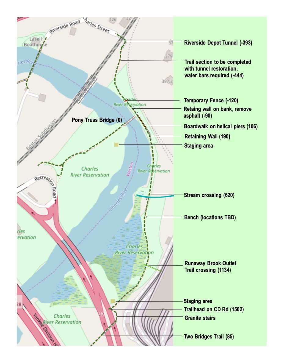
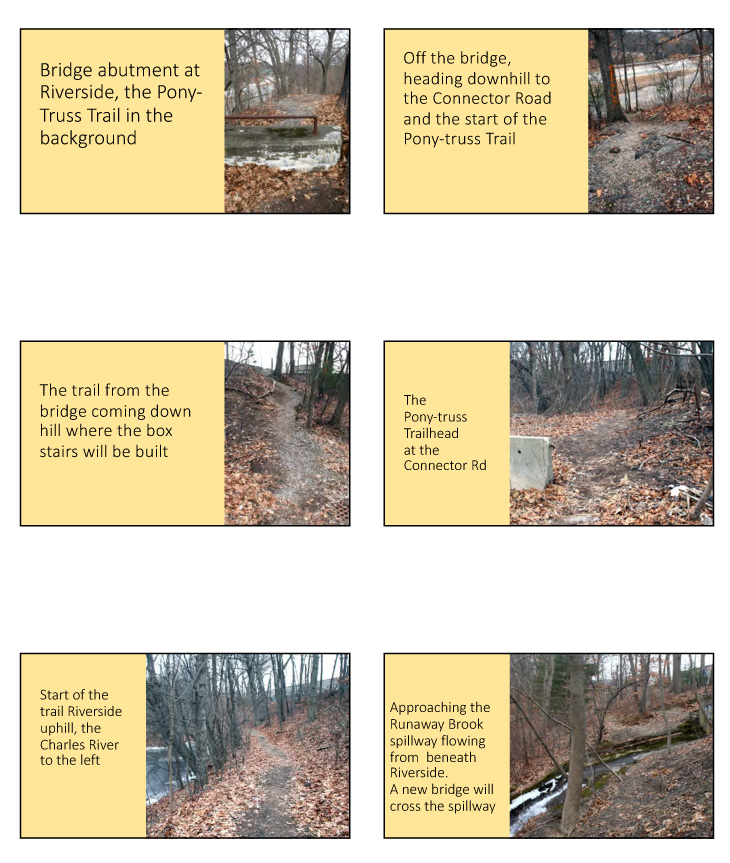
The Pony-Truss trail, named after the key trail landmark the Pony Truss Bridge, is identifiable on maps dating back to 1875; it provided a footpath for canoeists traveling from Boston on the trolley to Riverside Depot to walk to boathouses at Riverside Park across the Pony-truss bridge. The rerouting of the Lower Falls Branch of the Boston & Albany Railroad to its current location on the Newton (south) side of the Charles created a steep slope (approximately 40%) above the trail. Much of the trail overlies a sewer right-of-way parallel to the River edge. The trail is almost entirely on land owned and managed by the Department of Conservation and Recreation. The trail segment from Riverside Station and the Two Bridges Trail where box stairs will be built is owned by the Mass DOT. The entire trail is under the purview of the Newton Conservation Commission.
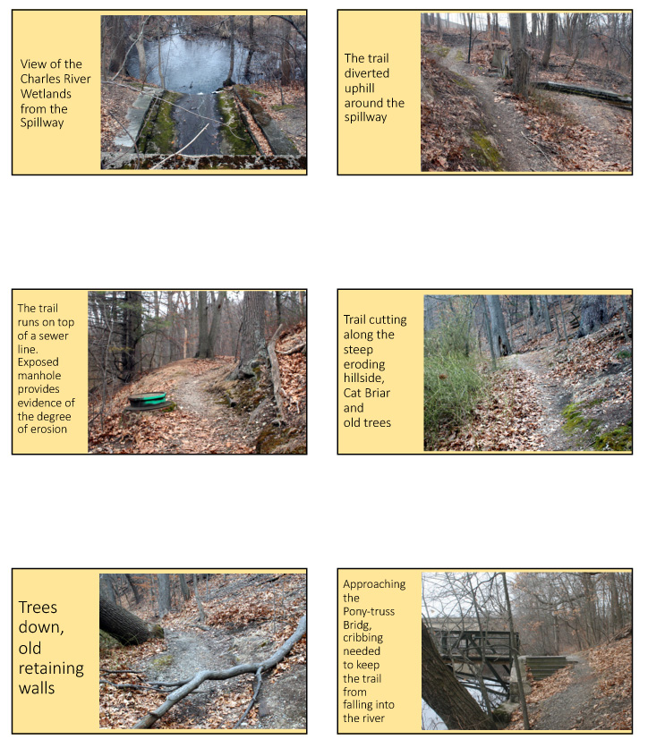
Currently the trail gets light use by local residents for walking, running, and off-road biking for recreation, access to parkland, and as transportation between Auburndale, Lower Falls and Riverside MBTA station. Between the effects of normal pedestrian wear and tear, decay of previous trail infrastructure, and the gradual downhill migration of the fill installed to create the rail line above the trail, the steep bank above the trail has eroded, placing segments of the trail just upstream from the Pony-truss bridge in danger of collapsing into the river. There is visible evidence of multiple attempts to reinforce the bank above and below the trail.
The creation of the Riverside MBTA station and the construction of the adjacent Riverside Center Office Park created large impermeable surfaces which buried Runaway Brook. This and a second stream exit the sites in large culverts and cross the trail emptying into the Charles River. The obstruction created by the concrete spillway for the Runaway Brook forced walkers to divert the path uphill. The plan is to reroute the path over a new footbridge constructed over the spillway that will also provide an outlook for hikers to pause and experience running water cascading into the Charles. On the Newton side of the Pony Truss Bridge a second accessible sitting area is planned for visitors to enjoy views of the river and the iconic arched bridge that carries the commuter rail line. The impending, large residential and commercial development at the Riverside MBTA station will increase use of this trail substantially.
Trail assessment
Anticipating the need for restoration work, in 2018 the RGWG, with funding from the Solomon Foundation, hired Andrew Norkin, Appalachian Mountain Club Director of Trails and Recreation Management, to assess the trail. The trail is approximately 2,000 feet long and for most of tis distance a has a width of 3-4 feet. It is generally level but rises at a 5-10% grade from the Pony Truss Bridge to reach the Depot Tunnel, where it ends crossing under the commuter rail tracks to Charles Street. The trail runs between the Riverside Depot Tunnel and the Collector-Distributor Road (original route of Rt. 128) at the Riverside MBTA Station. Access to the trail is from the CD road or Riverside Park across the Pony-Truss Bridge. (Trail diagrams)
The AMC assessment provided foot-by-foot recommendations and estimated costs for repairs and enhancements that will give the trail a second life. (see Appendix: AMC Assessment). The work outlined in this assessment will include regrading, clearing brush and several small trees, and installation of drainage features, retaining and crib walls, box-stairs, and a bridge. Professional trails crews will be required to do these repairs and create the new infrastructure. Accept where cribbing and retaining structures are need the area of disturbance will be no more than 4-6 feet, with an average finished trail width of 3 feet. Equipment used on the project may not exceed 48 inches. The goal is a resilient pedestrian trail with continuous views of a beautiful river. Other trails within the proposed Greenway will be shared-use and ADA-compliant.
Request for Proposals
On January 25th 2019 the Riverside Greenway Working Group (RGWG) publisized proposals from qualified firms for the restoration of the historic Pony Truss Trail on the Newton-side of the Charles River in Newton Massachusetts. We seek a professional trails firm that performs trail construction/restoration work and can work with and educate volunteer workers in trail building skills. The value of the contract will not exceed $42,000. The final deliverable will be a fully restored trail with the structures according to the specifications outlined in this request.
Volunteer Training
This work will be completed by December 2020 depending on the availability am appropriate vendor. The funding source for this project is the DCR-Recreational Trials Program, which requires a 20% match. We anticipate meeting this match with volunteer labor and foundation donations. More importantly, we view the presence of professional trail builders as a unique opportunity for volunteers to work-side by-side to receive on-the-job training in trails construction and maintenance. Our goal is for these trained volunteers to serve as core members of local trails crews that will themselves build and maintain other foot-trail segments within the Riverside Greenway network, as well as trails in the abutting communities of Wellesley and Weston.
If you want to volunteer to help rebuild this trail and receive professional trail-builiding training please contact us.
Address: Newton Lower Falls, MA 02462 |